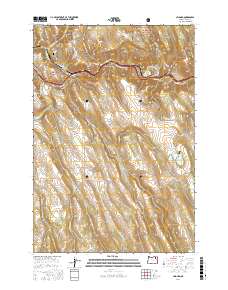
2017 Map of Hilgard
USGS Topo · Published 2017About this map
The Grande Ronde River carves a deep path through this portion of the Whitman National Forest, where the settlements of Hilgard and Perry sit along the winding river corridor. The landscape is defined by a complex network of drainages and family-named canyons, such as Blacksmith Canyon and Peach Canyon, that descend from high points like Mahogany Mtn.
Find a feature on this map
48 named features on this map. Tap any name to fly to it.
Don’t see what you’re looking for? This feature index may not catch every label — zoom into the map to look around manually.
Map Details
Editions of this 2017 Hilgard Map
This is the sole edition of this map. No revisions or reprints were ever made.
Other maps of this area

1953 · Pendleton
USGS Topo · 1:250,000

1956 · Pendleton
USGS Topo · 1:250,000

1963 · La Grande SE
USGS Topo · 1:24,000

1963 · Hilgard
USGS Topo · 1:24,000

1963 · Summerville
USGS Topo · 1:24,000

1964 · Huron
USGS Topo · 1:24,000

1964 · Drumhill Ridge
USGS Topo · 1:24,000

1964 · Kamela SE
USGS Topo · 1:24,000
1965 · Glass Hill
USGS Topo · 1:24,000

1965 · Little Beaver Creek
USGS Topo · 1:24,000