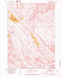
1951 Map of Hillberry Rim
USGS Topo · Published 1979About this map
Hillberry Rim defines the topography of this high-plateau region of Hot Springs County and Park County. The landscape is a complex network of dry draws and seasonal waterways, including the descriptively named Hole-in-the-Ground Creek and the meandering Buffalo Creek. This mid-century survey reflects a region primarily shaped by livestock ranching and the necessities of water management in a semi-arid environment, evidenced by the presence of Dickie Shearing Sheds and isolated water sources like Enright Reservoir and the Wilson Reservoirs.
Find a feature on this map
15 named features on this map. Tap any name to fly to it.
Don’t see what you’re looking for? This feature index may not catch every label — zoom into the map to look around manually.
Map Details
Editions of this 1951 Hillberry Rim Map
2 editions found
Other maps of this area

1911 · Meeteetse
USGS Topo · 1:62,500

1913 · Meeteetse
USGS Topo · 1:62,500

1913 · Grass Creek Basin
USGS Topo · 1:62,500

1915 · Grass Creek Basin
USGS Topo · 1:62,500

1951 · Hillberry Rim
USGS Topo · 1:24,000

1951 · Gillies Draw
USGS Topo · 1:24,000

1951 · Wilson Spring
USGS Topo · 1:24,000

1951 · Dead Indian Hill
USGS Topo · 1:24,000

1955 · Cody
USGS Topo · 1:250,000

1955 · Thermopolis
USGS Topo · 1:250,000