1952 Map of Hilldale
USGS Topo · Published 1979About this map
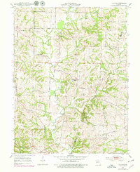
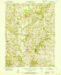
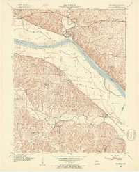
Moniteau Creek and its many winding tributaries, including Hunters Creek and Prairie Creek, dominate this central Missouri landscape. The settlement patterns in the mid-20th century reflect a highly localized rural society, where small communities like Hilldale and Ashland were anchored by neighborhood institutions. A notable density of country schools appears across the township lines of Richmond, Moniteau, and Perche, such as Jackson Sch, Walnut Shade Sch, and Union Sch, indicating the historical footprint of rural education before large-scale district consolidation. Faith and memory are well-represented by landmarks like Smith Chapel and Sulphur Springs Ch, alongside family-named burial sites including Ricketts Cem and Hourigan Cem. The presence of Big Spring near the Howard Co Boone Co boundary further highlights the reliance on natural water sources in this agricultural region.
Find a feature on this map
22 named features on this map. Tap any name to fly to it.
Don’t see what you’re looking for? This feature index may not catch every label — zoom into the map to look around manually.
Map Details
Editions of this 1952 Hilldale Map
2 editions found
Other maps of this area

1886 · Jefferson City
USGS Topo · 1:125,000

1888 · Boonville
USGS Topo · 1:125,000

1890 · Moberly
USGS Topo · 1:125,000

1890 · Glasgow
USGS Topo · 1:125,000

1894 · Jefferson City
USGS Topo · 1:125,000

1917 · Sturgeon
USGS Topo · 1:62,500

1947 · Jefferson City
USGS Topo · 1:250,000
1948 · Columbia
USGS Topo · 1:62,500
1950 · Columbia
USGS Topo · 1:62,500
1952 · Rocheport
USGS Topo · 1:24,000