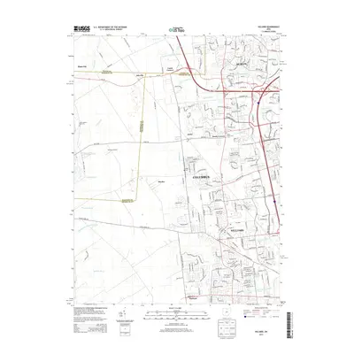
2013 Map of Hilliard
USGS Topo · Published 2013About this map
Hilliard and Dublin anchor this western Franklin County landscape, showing the suburban expansion of Columbus in the early 21st century. While residential developments and modern roadway networks like Oh-161 dominate the eastern half, the western edges near the Union and Madison County lines retain traces of an older rural character. Scattered family and community landmarks such as Smith-Calhoun Road Cem, Rings Cem, and the historic Saint John Cem provide essential anchor points for genealogists. The map also documents smaller unincorporated settlements and crossroads like Kileville, Amlin, and Mudsock that have persisted amidst the growing urban footprint. Drainage and irrigation remain central to the geography here, with an intricate system of agricultural waterways including Cramer Ditch, Ballenger Ditch, and Gordon Tri-County Ditch defining the local hydrology.
Find a feature on this map
165 named features on this map. Tap any name to fly to it.
Don’t see what you’re looking for? This feature index may not catch every label — zoom into the map to look around manually.
Map Details
Editions of this 2013 Hilliard Map
This is the sole edition of this map. No revisions or reprints were ever made.
Other maps of this area

1901 · Dublin
USGS Topo · 1:62,500

1903 · Dublin
USGS Topo · 1:62,500

1907 · London
USGS Topo · 1:62,500

1916 · Milford Center
USGS Topo · 1:62,500

1923 · West Columbus
USGS Topo · 1:62,500

1925 · West Columbus
USGS Topo · 1:62,500

1944 · Milford Center
USGS Topo · 1:62,500

1947 · Columbus
USGS Topo · 1:250,000

1950 · Marion
USGS Topo · 1:250,000
1954 · Shawnee Hills
USGS Topo · 1:24,000