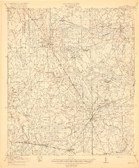
1919 Map of Hilliard
USGS Topo · Published 1919About this map
The St Marys River and its complex network of tributaries like Little Boggy Swamp and Mills Swamp define the landscape of northern Florida just after the First World War. This territory, surveyed by W.S. Beames and others from the U.S. Geological Survey, reveals a region heavily reliant on its rail corridors and timber resources. The Atlantic Coast Line and Seaboard Air Line provide the primary north-south infrastructure, connecting established settlements like Hilliard and Callahan with industrial outposts such as Cummers Camp. Cultural life is marked by several rural schoolhouses, including the Romulus School and Mill Creek School, while local industry is anchored by Nelsons Mill and Hodges Mill. The presence of Ferry Road and Fernandina Road highlights the early overland routes used before modern highway expansion transformed the county.
Find a feature on this map
41 named features on this map. Tap any name to fly to it.
Don’t see what you’re looking for? This feature index may not catch every label — zoom into the map to look around manually.
Map Details
Editions of this 1919 Hilliard Map
3 editions found

Other maps of this area

1917 · Cambon
USGS Topo · 1:62,500

1917 · Boulogne
USGS Topo · 1:62,500

1917 · Macclenny
USGS Topo · 1:62,500

1917 · Hilliard
USGS Topo · 1:62,500

1918 · St Marys
USGS Topo · 1:62,500

1918 · Folkston
USGS Topo · 1:62,500

1918 · Moniac
USGS Topo · 1:62,500

1918 · Cambon
USGS Topo · 1:62,500

1918 · Jacksonville
USGS Topo · 1:62,500

1918 · Kingsland
USGS Topo · 1:62,500