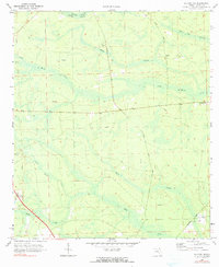
1970 Map of Hilliard NE
USGS Topo · Published 1990About this map
Cabbage Creek Swamp and White Oak Swamp dominate this low-lying landscape in Nassau County, where the intricate drainage patterns of the Little St Marys River define the local geography. Small rural settlements like Evergreen and Lessie serve as anchors for the local community, which is largely organized around agricultural and timber land. The prevalence of firebreaks and jeep trails across the sheet indicates an area heavily involved in managed forestry during the early 1970s.
Find a feature on this map
19 named features on this map. Tap any name to fly to it.
Don’t see what you’re looking for? This feature index may not catch every label — zoom into the map to look around manually.
Map Details
Editions of this 1970 Hilliard NE Map
3 editions found
Other maps of this area

1917 · Boulogne
USGS Topo · 1:62,500

1917 · Hilliard
USGS Topo · 1:62,500

1918 · St Marys
USGS Topo · 1:62,500

1918 · Kingsland
USGS Topo · 1:62,500

1919 · St Marys
USGS Topo · 1:62,500

1919 · Hilliard
USGS Topo · 1:62,500

1919 · Boulogne
USGS Topo · 1:62,500

1948 · Jacksonville
USGS Topo · 1:250,000

1957 · Jacksonville
USGS Topo · 1:250,000

1958 · Gross
USGS Topo · 1:24,000