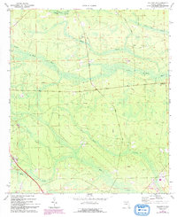
1970 Map of Hilliard NE
USGS Topo · Published 1992About this map
The Little St Marys River meanders through the heart of this Nassau County landscape, defining a region characterized by expansive wetlands and scattered rural settlements. Surveyed in 1970 and revised in 1992, the map documents the quiet communities of Evergreen and Lessie at a time when much of the terrain remained under the cover of dense swamps. Extensive drainage patterns are visible through named features like Cabbage Creek Swamp, Wilder Swamp, and Mussel White Swamp, which dominate the low-lying interior.
Find a feature on this map
24 named features on this map. Tap any name to fly to it.
Don’t see what you’re looking for? This feature index may not catch every label — zoom into the map to look around manually.
Map Details
Editions of this 1970 Hilliard NE Map
3 editions found
Other maps of this area

1917 · Boulogne
USGS Topo · 1:62,500

1917 · Hilliard
USGS Topo · 1:62,500

1918 · St Marys
USGS Topo · 1:62,500

1918 · Kingsland
USGS Topo · 1:62,500

1919 · St Marys
USGS Topo · 1:62,500

1919 · Hilliard
USGS Topo · 1:62,500

1919 · Boulogne
USGS Topo · 1:62,500

1948 · Jacksonville
USGS Topo · 1:250,000

1957 · Jacksonville
USGS Topo · 1:250,000

1958 · Gross
USGS Topo · 1:24,000