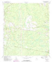
1970 Map of Hilliard SW
USGS Topo · Published 1992About this map
Kent and Crawford anchor the southern reaches of this Northeast Florida landscape, situated within a complex network of wetlands and drainage basins. Surveyed in 1970, the map illustrates how transportation corridors were etched into the low-lying terrain, including routes such as Irvin Ave and Quail Road. The area is defined by its intricate hydrology, where Alligator Creek and Deep Creek navigate through densely wooded marshes, a characteristic trait of the coastal plain environment before more intensive modern development. To the west, the small settlement of Cambrai sits near the rail line that connects these remote outposts. A single Radio Tower stands as a prominent man-made landmark amidst the extensive woodland and creek systems like Little Mills Creek and Mill Creek, providing a clear record of the rural infrastructure in Nassau County during the late twentieth century.
Find a feature on this map
10 named features on this map. Tap any name to fly to it.
Don’t see what you’re looking for? This feature index may not catch every label — zoom into the map to look around manually.
Map Details
Editions of this 1970 Hilliard SW Map
3 editions found
Other maps of this area

1917 · Cambon
USGS Topo · 1:62,500

1917 · Macclenny
USGS Topo · 1:62,500

1917 · Hilliard
USGS Topo · 1:62,500

1918 · Moniac
USGS Topo · 1:62,500

1918 · Cambon
USGS Topo · 1:62,500

1918 · Macclenny
USGS Topo · 1:62,500

1919 · Hilliard
USGS Topo · 1:62,500

1942 · Moniac
USGS Topo · 1:62,500

1948 · Jacksonville
USGS Topo · 1:250,000

1954 · Valdosta
USGS Topo · 1:250,000