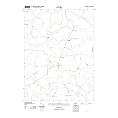
2010 Map of Hilliards
USGS Topo · Published 2010About this map
Annandale Sandstone Quarry sits in the northwest corner of this Butler County landscape, marking the industrial activity that defined parts of this region. The map reveals a network of small settlements and family-named junctions, such as Higgins Corner, Argentine, and Whiskerville, connected by a web of local roads like Old Brick Rd and Cemetery Rd. The topography is carved by several waterways, including the South Branch Slippery Rock Creek and Silver Creek, which likely supported early local industry such as Walley Mill. The arrangement of these hamlets suggests a rural development pattern common to Pennsylvania, where crossroads often evolved around specific local resources or familial homesteads. Significant community hubs like North Washington and Hilliards provide focal points for this 2010 topographic survey, preserving the names of various runs and small lakes like Harbar Acres Lake.
Find a feature on this map
79 named features on this map. Tap any name to fly to it.
Don’t see what you’re looking for? This feature index may not catch every label — zoom into the map to look around manually.
Map Details
Editions of this 2010 Hilliards Map
This is the sole edition of this map. No revisions or reprints were ever made.
Other maps of this area

1900 · Kittanning
USGS Topo · 1:62,500

1902 · Kittanning
USGS Topo · 1:62,500

1907 · Foxburg
USGS Topo · 1:62,500

1908 · Foxburg
USGS Topo · 1:62,500

1909 · Butler
USGS Topo · 1:62,500

1910 · Hilliards
USGS Topo · 1:62,500

1911 · Butler
USGS Topo · 1:62,500

1912 · Hilliards
USGS Topo · 1:62,500

1944 · Hilliards
USGS Topo · 1:62,500

1953 · Pittsburgh
USGS Topo · 1:250,000