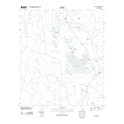
2010 Map of Hillister
USGS Topo · Published 2010About this map
Hillister and the neighboring residential community of Timber Lakes anchor this part of Tyler County, defined by a dense concentration of man-made lakes and dams. The landscape reflects a shift toward recreational and rural residential development, with numerous reservoirs such as Lake Charmaine, Boykin Lake Number 1, and Masterson Lake carved into the East Texas piney woods. The map preserves several important genealogical landmarks, including Mount Pisgah Cemetery, Justis Cemetery, and Williams Cemetery, which are tucked away near established routes like FM 256.
Find a feature on this map
87 named features on this map. Tap any name to fly to it.
Don’t see what you’re looking for? This feature index may not catch every label — zoom into the map to look around manually.
Map Details
Editions of this 2010 Hillister Map
This is the sole edition of this map. No revisions or reprints were ever made.
Other maps of this area

1954 · Beaumont
USGS Topo · 1:250,000

1955 · Woodville
USGS Topo · 1:62,500

1955 · Camden
USGS Topo · 1:62,500

1957 · Beaumont
USGS Topo · 1:250,000

1958 · Segno
USGS Topo · 1:62,500

1958 · Warren
USGS Topo · 1:62,500

1984 · Beaumont
USGS Topo · 1:250,000

1984 · Jacks Creek South
USGS Topo · 1:24,000

1984 · Jacks Creek North
USGS Topo · 1:24,000
1984 · Woodville
USGS Topo · 1:24,000