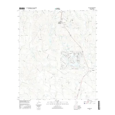
2016 Map of Hillister
USGS Topo · Published 2016About this map
Big Thicket National Preserve occupies the northern reaches of this East Texas terrain, protecting a dense network of watercourses and piney woods. The landscape is defined by the winding paths of Big Cypress Cr and Little Cypress Cr, which feed into an extensive system of private lakes and residential developments. The community of Ivanhoe stands out for its themed street names like Sir Henry Dr S and Galahad Loop Rd, reflecting a mid-century recreational layout centered around Lake Ivanhoe, Lake Charmaine, and Lake Galahad. To the southeast, the settlement of Hillister sits along the highway corridor, providing a more traditional residential anchor. Genealogists will find several small burial grounds scattered across the area, including Justis Cem near the center of the map and Williams Cem further south. This 2016 survey documents the modern intersection of conservation land and private residential lakefront life.
Find a feature on this map
128 named features on this map. Tap any name to fly to it.
Don’t see what you’re looking for? This feature index may not catch every label — zoom into the map to look around manually.
Map Details
Editions of this 2016 Hillister Map
This is the sole edition of this map. No revisions or reprints were ever made.
Other maps of this area

1954 · Beaumont
USGS Topo · 1:250,000

1955 · Woodville
USGS Topo · 1:62,500

1955 · Camden
USGS Topo · 1:62,500

1957 · Beaumont
USGS Topo · 1:250,000

1958 · Segno
USGS Topo · 1:62,500

1958 · Warren
USGS Topo · 1:62,500

1984 · Beaumont
USGS Topo · 1:250,000

1984 · Jacks Creek South
USGS Topo · 1:24,000

1984 · Jacks Creek North
USGS Topo · 1:24,000
1984 · Woodville
USGS Topo · 1:24,000