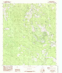
1984 Map of Hillister
USGS Topo · Published 1985About this map
Hillister and its surrounding timberlands characterize this East Texas landscape as it appeared in the mid-1980s. The settlement is centered near the junction of several drainage systems, most notably Big Cypress Creek and Turkey Creek. This area is defined by an extensive network of small lakes and ponds, many likely tied to the local lumber and timber industry indicated by the large Timber label on the sheet. Family and local history researchers will find several named water bodies including Masterson Lake, Spurlock Lake, and Reid Lake, alongside a local Cem located west of the main settlement. The map captures the intricate hydrology of the region, where numerous branches like Magnus Branch and Spurlock Branch feed into larger creeks, reflecting a landscape shaped by water and woodland resources before modern large-scale development shifted the rural character.
Find a feature on this map
22 named features on this map. Tap any name to fly to it.
Don’t see what you’re looking for? This feature index may not catch every label — zoom into the map to look around manually.
Map Details
Editions of this 1984 Hillister Map
This is the sole edition of this map. No revisions or reprints were ever made.
Other maps of this area

1954 · Beaumont
USGS Topo · 1:250,000

1955 · Woodville
USGS Topo · 1:62,500

1955 · Camden
USGS Topo · 1:62,500

1957 · Beaumont
USGS Topo · 1:250,000

1958 · Segno
USGS Topo · 1:62,500

1958 · Warren
USGS Topo · 1:62,500

1984 · Beaumont
USGS Topo · 1:250,000

1984 · Jacks Creek South
USGS Topo · 1:24,000

1984 · Jacks Creek North
USGS Topo · 1:24,000
1984 · Woodville
USGS Topo · 1:24,000