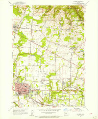
1954 Map of Hillsboro
USGS Topo · Published 1956About this map
Hillsboro serves as the focal point of this mid-century survey, surrounded by a transition from organized town grids to expansive Tualatin Valley agricultural lands. The landscape is defined by its transit networks, including the Southern Pacific and Oregon Electric railroads, which linked outlying communities like Orenco and Reedville to the regional hub. Local history is anchored by the Historic Marker (Joseph L Meek Land Claim) and early community sites such as West Union Cem and the Tualatin Plains Cem. North of the Hillsboro Airport, the terrain rises toward the Tualatin Mountains, where smaller settlements like Helvetia and North Plains are connected by roads like West Union Road. This record documents the area just before the significant suburban expansion of the later twentieth century, when the County Fairgrounds and local schools like Union H S were central to civic life.
Find a feature on this map
60 named features on this map. Tap any name to fly to it.
Don’t see what you’re looking for? This feature index may not catch every label — zoom into the map to look around manually.
Map Details
Editions of this 1954 Hillsboro Map
This is the sole edition of this map. No revisions or reprints were ever made.
Other maps of this area

1915 · Hillsboro
USGS Topo · 1:62,500

1916 · Tualatin
USGS Topo · 1:62,500

1918 · Hillsboro
USGS Topo · 1:62,500

1939 · Tualatin
USGS Topo · 1:62,500

1940 · Tualatin
USGS Topo · 1:62,500

1940 · Hillsboro
USGS Topo · 1:62,500

1941 · Gales Creek
USGS Topo · 1:62,500

1941 · Yamhill
USGS Topo · 1:62,500

1942 · Yamhill
USGS Topo · 1:62,500

1948 · Vancouver
USGS Topo · 1:250,000