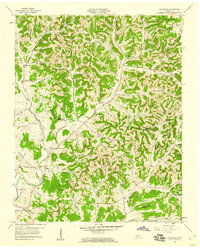
1959 Map of Hillsdale
USGS Topo · Published 1960About this map
Hillsdale and the surrounding drainages of Goose Creek and Dixon Creek define this landscape in north-central Tennessee during the late 1950s. The settlement pattern is deeply connected to the narrow valleys and hollows, such as Sanders Hollow and Wright Hollow, where family farms and small communities like Meadorville and Beech Grove are situated. The map captures a transition between the more established Macon and Trousdale county lines, marked by numerous small family cemeteries and country churches that anchor the local genealogy.
Find a feature on this map
73 named features on this map. Tap any name to fly to it.
Don’t see what you’re looking for? This feature index may not catch every label — zoom into the map to look around manually.
Map Details
Editions of this 1959 Hillsdale Map
2 editions found
Other maps of this area

1931 · Lafayette
USGS Topo · 1:62,500

1931 · Red Boiling Springs
USGS Topo · 1:62,500

1932 · Carthage
USGS Topo · 1:62,500

1956 · Corbin
USGS Topo · 1:250,000

1956 · Nashville
USGS Topo · 1:250,000

1958 · Corbin
USGS Topo · 1:250,000

1958 · Westmoreland
USGS Topo · 1:24,000

1958 · Bellwood
USGS Topo · 1:24,000

1958 · Dixon Springs
USGS Topo · 1:24,000
1958 · Lafayette
USGS Topo · 1:24,000