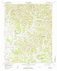
1959 Map of Hillsdale
USGS Topo · Published 1984About this map
Goose Creek and Dixon Creek carve through the high ridges of north-central Tennessee in this mid-century portrait of a rural upland landscape. The terrain is defined by a dense network of named hollows, such as Woodmore Hollow and Blankenship Hollow, where small agricultural communities like Hillsdale and Meadorville took root. The settlement pattern follows the valley floors and narrow gaps, with local life centered around institutions like Hillsdale Ch and several small family burial grounds, including Wallace Cem and Fleeman Cem.
Find a feature on this map
64 named features on this map. Tap any name to fly to it.
Don’t see what you’re looking for? This feature index may not catch every label — zoom into the map to look around manually.
Map Details
Editions of this 1959 Hillsdale Map
2 editions found
Other maps of this area

1931 · Lafayette
USGS Topo · 1:62,500

1931 · Red Boiling Springs
USGS Topo · 1:62,500

1932 · Carthage
USGS Topo · 1:62,500

1956 · Corbin
USGS Topo · 1:250,000

1956 · Nashville
USGS Topo · 1:250,000

1958 · Corbin
USGS Topo · 1:250,000

1958 · Westmoreland
USGS Topo · 1:24,000

1958 · Bellwood
USGS Topo · 1:24,000

1958 · Dixon Springs
USGS Topo · 1:24,000
1958 · Lafayette
USGS Topo · 1:24,000