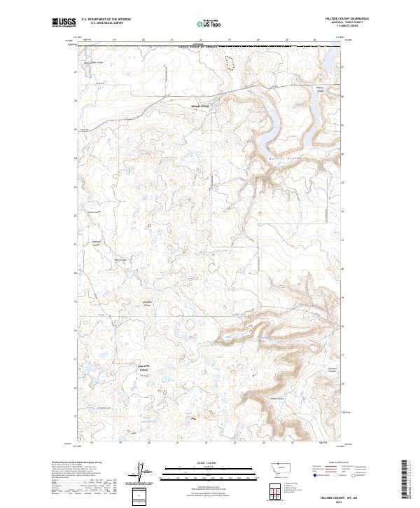
2024 Map of Hillside Colony
USGS Topo · Published 2024About this map
The northern edge of Toole County meets the international border in this contemporary survey of a specialized agricultural landscape. Settlement is concentrated at Hillside Colony and Rim Rock Colony, communal outposts defined by their proximity to the network of coulees and seasonal water sources. The terrain is deeply inscribed by drainage patterns, including the long reaches of Buckley Coulee and Johns Coulee, which traverse the high plains toward the Red River. To the south, a cluster of small basins holds Twin Lakes, Hemmings Lake, and the Benton Trail Lakes, providing vital surface water in an otherwise semi-arid environment. The road network, including Little Jerusalem and W Sweetgrass, follows the township and range lines, reflecting the enduring legacy of the Public Land Survey System in organizing Montana's rural interior.
Find a feature on this map
30 named features on this map. Tap any name to fly to it.
Don’t see what you’re looking for? This feature index may not catch every label — zoom into the map to look around manually.
Map Details
Editions of this 2024 Hillside Colony Map
This is the sole edition of this map. No revisions or reprints were ever made.
Other maps of this area

1909 · Cut Bank
USGS Topo · 1:125,000

1912 · Cut Bank
USGS Topo · 1:125,000

1939 · Sunburst
USGS Topo · 1:62,500

1954 · Shelby
USGS Topo · 1:250,000

1958 · Shelby
USGS Topo · 1:250,000

1960 · Cut Bank
USGS Topo · 1:250,000

1963 · Cut Bank
USGS Topo · 1:250,000

1964 · Cut Bank
USGS Topo · 1:250,000
1968 · Hillside Colony
USGS Topo · 1:24,000
1968 · Mountain View School
USGS Topo · 1:24,000