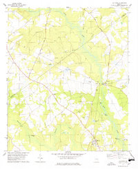
1978 Map of Hilltonia
USGS Topo · Published 1978About this map
Brier Creek defines the eastern boundary of this Screven County landscape, winding past historical river access points like Red Bluff Landing and Rice Landing. The 1970s terrain is marked by a high density of rural religious and family landmarks, including Mills Grove Ch, Canaan Ch, and Bethlehem Cem. The settlement of Hilltonia anchors the southern portion of the map, while Millhaven serves as a secondary hub near the Millhaven Airport. This survey provides unique topographical detail of the local water system, from the Hills Millpond and Ski Pond to the network of branches such as Comers Branch and Chandlers Branch. The inclusion of fine red dashed lines for selected fence and field lines offers genealogists and local historians a specific look at the agricultural footprint and property divisions of the late 20th century.
Find a feature on this map
40 named features on this map. Tap any name to fly to it.
Don’t see what you’re looking for? This feature index may not catch every label — zoom into the map to look around manually.
Map Details
Editions of this 1978 Hilltonia Map
This is the sole edition of this map. No revisions or reprints were ever made.
Other maps of this area

1920 · Ellenton
USGS Topo · 1:48,000

1920 · Hilltonia
USGS Topo · 1:62,500

1920 · Millen
USGS Topo · 1:62,500

1920 · Greens Cut
USGS Topo · 1:62,500

1921 · Ellenton
USGS Topo · 1:62,500

1943 · Hilltonia
USGS Topo · 1:62,500

1943 · Greens Cut
USGS Topo · 1:62,500

1943 · Millen
USGS Topo · 1:62,500

1943 · Augusta East
USGS Topo · 1:125,000

1943 · Millen
USGS Topo · 1:125,000