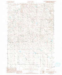
1983 Map of Hilltop Diamond Ring Ranch
USGS Topo · Published 1994About this map
Hilltop Diamond Ring Ranch and other named homesteads anchor this 1980s topographical survey of central South Dakota. The landscape is defined by the drainage basins of Plum Creek, Cottonwood Creek, and Mule Creek, where intermittent watercourses have carved distinct breaks into the prairie terrain. Human activity is sparse and centered on livestock operations, as evidenced by the distribution of the Golden Willow Ranch, Willoughby Ranch, and Foland Ranch.
Find a feature on this map
15 named features on this map. Tap any name to fly to it.
Don’t see what you’re looking for? This feature index may not catch every label — zoom into the map to look around manually.
Map Details
Editions of this 1983 Hilltop Diamond Ring Ranch Map
2 editions found
Other maps of this area

1954 · Pierre
USGS Topo · 1:250,000

1958 · Pierre
USGS Topo · 1:250,000

1982 · Midland NW
USGS Topo · 1:24,000

1982 · May Ranch
USGS Topo · 1:24,000

1983 · Bentley Ranch
USGS Topo · 1:24,000

1983 · Mule Creek
USGS Topo · 1:24,000

1983 · Philip
USGS Topo · 1:100,000

1983 · Moenville
USGS Topo · 1:24,000

1983 · Middle Draw
USGS Topo · 1:24,000

1983 · Powell NW
USGS Topo · 1:24,000