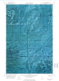
1974 Map of Hilman Lake
USGS Topo · Published 1975About this map
Red Lake State Wildlife Management Area and the Beltrami Island State Forest dominate this northern Minnesota landscape as it appeared in the mid-1970s. This orthophotomap, produced from late 1960s aerial photography, reveals the intricate drainage patterns and boggy terrain across the boundary between Lake of the Woods County and Beltrami County. The southern portion of the sheet captures a segment of the Red Lake Indian Reservation, showing the stark lack of road infrastructure and the dominance of natural features like Miller Cr and the small, central Hilman Lake. The photographic base provides an authentic record of the region's wetlands and timber patterns before modern forest management or climate shifts altered the surface hydrology of these protected state and tribal lands.
Find a feature on this map
6 named features on this map. Tap any name to fly to it.
Don’t see what you’re looking for? This feature index may not catch every label — zoom into the map to look around manually.
Map Details
Editions of this 1974 Hilman Lake Map
This is the sole edition of this map. No revisions or reprints were ever made.
Other maps of this area

1919 · G
USGS Topo · 1:62,500

1919 · Fox
USGS Topo · 1:62,500

1919 · Ponemah
USGS Topo · 1:62,500

1919 · Knutson
USGS Topo · 1:62,500

1943 · Ponemah
USGS Topo · 1:62,500

1954 · Roseau
USGS Topo · 1:250,000

1957 · Roseau
USGS Topo · 1:250,000

1958 · Roseau
USGS Topo · 1:250,000
1973 · Waskish NW
USGS Topo · 1:24,000
1973 · Chase Brook
USGS Topo · 1:24,000