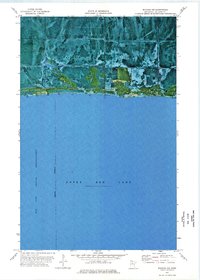
1973 Map of Waskish NW
USGS Topo · Published 1976About this map
Upper Red Lake dominates the southern half of this orthophotomap, its northern shoreline defined by an indefinite boundary that separates the open water from the marshy lowlands of Beltrami County. This 1970s record shows the northern fringe of the Red Lake Indian Reservation meeting the expansive Red Lake Wildlife Management Area. The landscape is a complex pattern of wetlands and forest, navigated primarily by Blanchard Road which skirts the lake's edge. Human activity in this remote region is marked by a specialized Rice Field and a small Gravel Pit, indicating the seasonal and resource-based economy of the shoreline. The transition from the massive water body to the protected wildlife zones provides a clear view of the natural management boundaries in Northern Minnesota during the early 1970s.
Find a feature on this map
9 named features on this map. Tap any name to fly to it.
Don’t see what you’re looking for? This feature index may not catch every label — zoom into the map to look around manually.
Map Details
Editions of this 1973 Waskish NW Map
This is the sole edition of this map. No revisions or reprints were ever made.
Other maps of this area

1919 · G
USGS Topo · 1:62,500

1919 · Fox
USGS Topo · 1:62,500

1919 · Ponemah
USGS Topo · 1:62,500

1919 · Knutson
USGS Topo · 1:62,500

1943 · Ponemah
USGS Topo · 1:62,500

1954 · Roseau
USGS Topo · 1:250,000

1957 · Roseau
USGS Topo · 1:250,000

1958 · Roseau
USGS Topo · 1:250,000
1973 · Ludlow Lookout Tower
USGS Topo · 1:24,000
1973 · Chase Brook SW
USGS Topo · 1:24,000