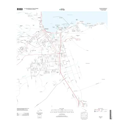
2013 Map of Hilo
USGS Topo · Published 2013About this map
The Lava Flow of 1881 provides a remarkable geologic anchor for this Hilo landscape, cutting a path through the modern street grid toward the shores of Hilo Bay. The map documents a complex mix of urban development and agricultural history, with residential neighborhoods like Keaukaha and Wainaku sitting alongside industrial landmarks such as the Hilo International Airport. Local history researchers will find several named camps, including 'Amauulu Camp and Eight and One Half Mile Camp, which point to the area's deep-rooted plantation heritage.
Find a feature on this map
289 named features on this map. Tap any name to fly to it.
Don’t see what you’re looking for? This feature index may not catch every label — zoom into the map to look around manually.
Map Details
Editions of this 2013 Hilo Map
This is the sole edition of this map. No revisions or reprints were ever made.
Other maps of this area

1915 · Honomu
USGS Topo · 1:62,500

1917 · Hilo
USGS Topo · 1:62,500

1924 · Makuu
USGS Topo · 1:62,500

1932 · Hilo
USGS Topo · 1:62,500

1954 · Hawaii North
USGS Topo · 1:250,000

1959 · Hawaii North
USGS Topo · 1:250,000

1961 · Hawaii North
USGS Topo · 1:250,000
1963 · Puu Makaala
USGS Topo · 1:24,000
1963 · Piihonua
USGS Topo · 1:24,000
1963 · Hilo
USGS Topo · 1:24,000