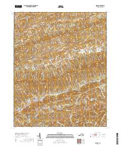
2019 Map of Hiltons
USGS Topo · Published 2019About this map
Clinch Mountain serves as the dominant spine of this Scott County landscape, separating the parallel drainage systems of the North Fork Holston River and Big Moccasin Creek. The settlement pattern reflects the area's complex ridge-and-valley topography, with small communities like Snowflake, Nickelsville, and Hiltons situated along narrow valleys and historical gaps. Local history and genealogy are anchored by a high density of family-named cemeteries, including the Dean Family Cem, Francisco Cem, and McMurray Cem, alongside landmarks such as McConnell Mill and the early defensive site at Dorton Fort. The river systems have dictated both transport and industry, with notable features like Bald Alley Bluff overlooking the Holston and various gaps like Eddington Gap providing essential passage through the steep terrain of Moccasin Ridge and Pine Ridge.
Find a feature on this map
110 named features on this map. Tap any name to fly to it.
Don’t see what you’re looking for? This feature index may not catch every label — zoom into the map to look around manually.
Map Details
Editions of this 2019 Hiltons Map
This is the sole edition of this map. No revisions or reprints were ever made.
Other maps of this area

1894 · Estillville
USGS Topo · 1:125,000

1897 · Bristol
USGS Topo · 1:125,000

1902 · Bristol
USGS Topo · 1:125,000

1920 · Wise
USGS Topo · 1:48,000

1920 · Coeburn
USGS Topo · 1:48,000

1921 · Wise
USGS Topo · 1:62,500

1935 · Hilton
USGS Topo · 1:24,000

1935 · Moggasin
USGS Topo · 1:48,000

1935 · Mendota
USGS Topo · 1:24,000

1935 · Blountville
USGS Topo · 1:24,000