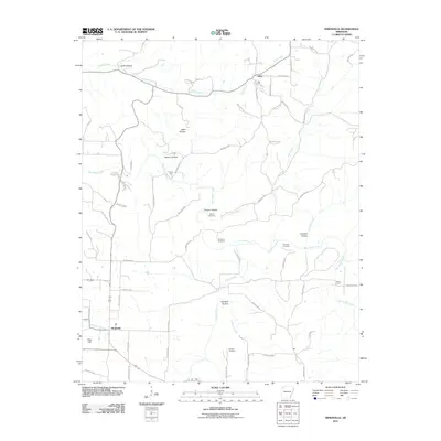
2011 Map of Hindsville
USGS Topo · Published 2011About this map
Hindsville sits at the southwestern edge of this Ozark landscape, where the Whitener Branch and Glade Creek converge. The terrain is defined by a dense network of hollows and ridges, including Lynch Hollow and Hartwell Hollow, centered around the winding course of War Eagle Creek. This watercourse is punctuated by historic crossing points such as Parker Ford and Rocky Ford, reflecting the traditional geography of Madison County before modern bridge infrastructure dominated the region.
Find a feature on this map
71 named features on this map. Tap any name to fly to it.
Don’t see what you’re looking for? This feature index may not catch every label — zoom into the map to look around manually.
Map Details
Editions of this 2011 Hindsville Map
This is the sole edition of this map. No revisions or reprints were ever made.
Other maps of this area

1900 · Eureka Springs
USGS Topo · 1:125,000

1901 · Eureka Springs
USGS Topo · 1:125,000

1945 · Harrison
USGS Topo · 1:250,000

1949 · Harrison
USGS Topo · 1:250,000

1954 · Harrison
USGS Topo · 1:250,000

1957 · Mundell
USGS Topo · 1:24,000

1957 · War Eagle
USGS Topo · 1:24,000
1958 · Goshen
USGS Topo · 1:24,000
1958 · Spring Valley
USGS Topo · 1:24,000

1958 · Hindsville
USGS Topo · 1:24,000