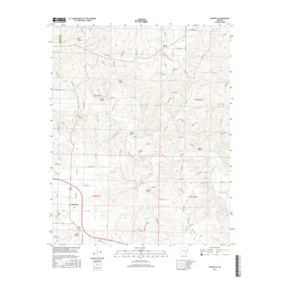
2017 Map of Hindsville
USGS Topo · Published 2017About this map
Hindsville and the smaller settlement of Clifty anchor this Madison County landscape, where the terrain is deeply defined by a network of creeks and named hollows. The winding course of War Eagle Cr and its tributaries, such as Clear Cr and Glade Cr, carve through the Ozark plateau, creating prominent relief at Keefer Mtn and Tater Hill. Local genealogy is well-preserved through several small burial sites, including Martin Cem, Bohannan Cem, and Cannady Cem, which are tucked away near the drainages of Poyner Hollow and Houston Hollow. The road network reflects the difficult topography, with routes like Madison 8200 following the high ridges while others descend into the narrow valleys. This 2017 survey provides a detailed view of a rural Arkansas community where land ownership patterns remain tied to the rugged physical geography of the hollows.
Find a feature on this map
136 named features on this map. Tap any name to fly to it.
Don’t see what you’re looking for? This feature index may not catch every label — zoom into the map to look around manually.
Map Details
Editions of this 2017 Hindsville Map
This is the sole edition of this map. No revisions or reprints were ever made.
Other maps of this area

1900 · Eureka Springs
USGS Topo · 1:125,000

1901 · Eureka Springs
USGS Topo · 1:125,000

1945 · Harrison
USGS Topo · 1:250,000

1949 · Harrison
USGS Topo · 1:250,000

1954 · Harrison
USGS Topo · 1:250,000

1957 · Mundell
USGS Topo · 1:24,000

1957 · War Eagle
USGS Topo · 1:24,000
1958 · Goshen
USGS Topo · 1:24,000
1958 · Spring Valley
USGS Topo · 1:24,000

1958 · Hindsville
USGS Topo · 1:24,000