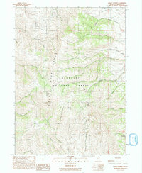
1991 Map of Hinkey Summit
USGS Topo · Published 1991About this map
Santa Rosa Range high country defines this 1991 provisional survey of north-central Nevada. The landscape is characterized by its high-altitude water systems and early-stage mineral exploration, marked by numerous labels for Prospect and Prospects scattered across the northern slopes. The map details the central drainage of the Humboldt National Forest, where the North Fork, Middle Fork, and South Fork converge. Infrastructure is sparse, concentrated at the Martin Creek Guard Sta and the Radio Facility near Hinkey Summit. Local activity centers on seasonal use and resource management, evidenced by the Campground near Lye Creek and the presence of the Gravel Pit in the eastern flats. Named landmarks like Chocolate Mtn and Granite Peak serve as primary navigational anchors for this remote mountainous terrain.
Find a feature on this map
35 named features on this map. Tap any name to fly to it.
Don’t see what you’re looking for? This feature index may not catch every label — zoom into the map to look around manually.
Map Details
Editions of this 1991 Hinkey Summit Map
This is the sole edition of this map. No revisions or reprints were ever made.
Other maps of this area

1882 · Paradise
USGS Topo · 1:250,000

1893 · Paradise
USGS Topo · 1:250,000

1955 · McDermitt
USGS Topo · 1:250,000

1959 · McDermitt
USGS Topo · 1:250,000

1959 · McDermitt
USGS Topo · 1:62,500

1959 · Hinkey Summit
USGS Topo · 1:62,500

1980 · Black Ridge
USGS Topo · 1:24,000

1980 · Spring City
USGS Topo · 1:24,000
1980 · Holloway Meadows
USGS Topo · 1:24,000

1985 · Quinn River Valley
USGS Topo · 1:100,000