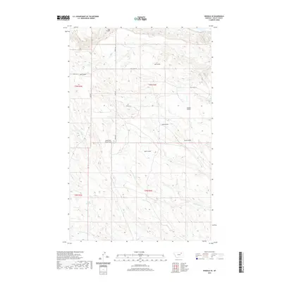
2020 Map of Hinsdale SE
USGS Topo · Published 2020About this map
Ruby Reservoir sits within a complex network of dry coulees and seasonal creeks in this rural section of Valley County. The landscape is defined by the repetitive patterns of the Public Land Survey System, with township boundaries like t30n r36e and t29n r36e dividing the high plains. Water management and drainage are central to the terrain, as seen in the numerous named coulees including Buffalo Coulee, Mott Coulee, and Ash Coulee that carve through the local topography. Transportation across this portion of the Montana plains is maintained through a grid of backroads and trails such as S Bench RD, Porteen RD, and the Valley View TRL. These routes link the scattered resources of the region, where the Hardscrabble Cr and N Fork Antelope Cr provide essential drainage for the surrounding ranchlands.
Find a feature on this map
21 named features on this map. Tap any name to fly to it.
Don’t see what you’re looking for? This feature index may not catch every label — zoom into the map to look around manually.
Map Details
Editions of this 2020 Hinsdale SE Map
This is the sole edition of this map. No revisions or reprints were ever made.
Other maps of this area

1906 · Hinsdale Special Map
USGS Topo · 1:62,500

1943 · Glasgow
USGS Topo · 1:125,000

1954 · Glasgow
USGS Topo · 1:250,000

1957 · Glasgow
USGS Topo · 1:250,000

1958 · Glasgow
USGS Topo · 1:250,000

1958 · Miller Coulee
USGS Topo · 1:62,500
1958 · Billick Coulee
USGS Topo · 1:24,000

1969 · Vandalia
USGS Topo · 1:24,000

1969 · Ellsworth Coulee
USGS Topo · 1:24,000
1984 · Hardpan Coulee
USGS Topo · 1:24,000