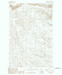
1984 Map of Hinsdale SE
USGS Topo · Published 1984About this map
The high plains of Valley County are defined by a complex network of seasonal drainages and small-scale water management. This landscape, as it appeared in the mid-1980s, is shaped by significant coulees and the headwaters of several creeks. Ruby Reservoir stands out as a primary water source in this semi-arid region, supporting the local ranching economy. The drainage patterns are dominated by the Ash Coulee and Bob Coulee systems, which channel runoff through the breaks. Further south, the terrain opens into the valleys of North Fork Antelope Creek and South Fork Antelope Creek, while Hardscrabble Creek cuts across the eastern portion of the quadrangle. The lack of concentrated settlements highlights the area's use for grazing and the importance of every named water feature for navigating and managing the range.
Find a feature on this map
7 named features on this map. Tap any name to fly to it.
Don’t see what you’re looking for? This feature index may not catch every label — zoom into the map to look around manually.
Map Details
Editions of this 1984 Hinsdale SE Map
This is the sole edition of this map. No revisions or reprints were ever made.
Other maps of this area

1906 · Hinsdale Special Map
USGS Topo · 1:62,500

1943 · Glasgow
USGS Topo · 1:125,000

1954 · Glasgow
USGS Topo · 1:250,000

1957 · Glasgow
USGS Topo · 1:250,000

1958 · Glasgow
USGS Topo · 1:250,000

1958 · Miller Coulee
USGS Topo · 1:62,500
1958 · Billick Coulee
USGS Topo · 1:24,000

1969 · Vandalia
USGS Topo · 1:24,000

1969 · Ellsworth Coulee
USGS Topo · 1:24,000
1984 · Hardpan Coulee
USGS Topo · 1:24,000