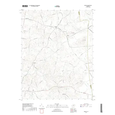
2019 Map of Hiseville
USGS Topo · Published 2019About this map
Hiseville and Griderville anchor this portion of the Barren County landscape, where the karst topography of south-central Kentucky is evidenced by numerous small depressions and sinkholes scattered throughout the terrain. The settlement pattern follows the local road network, connecting established communities like Coral Hill, Lecta, and Halfway across a region defined by the headwaters of several drainages. Significant elevation markers include Winlock Knob and Buck Knob to the east, providing vertical contrast to the winding paths of Beaver Creek and Barren Fork. For researchers, the presence of the Arnett Cem near Slick Rock provides a specific point of interest for genealogical study. The boundary between Barren County and Metcalfe County is clearly delineated along the eastern edge of the survey area, tracing the rural divide between these two central Kentucky districts.
Find a feature on this map
86 named features on this map. Tap any name to fly to it.
Don’t see what you’re looking for? This feature index may not catch every label — zoom into the map to look around manually.
Map Details
Editions of this 2019 Hiseville Map
This is the sole edition of this map. No revisions or reprints were ever made.
Other maps of this area

1935 · Horse Cave
USGS Topo · 1:48,000

1938 · Horse Cave
USGS Topo · 1:62,500

1953 · Sulphur Well
USGS Topo · 1:24,000

1953 · Temple Hill
USGS Topo · 1:24,000

1953 · Glasgow South
USGS Topo · 1:24,000

1953 · Summer Shade
USGS Topo · 1:24,000

1953 · Center
USGS Topo · 1:24,000

1954 · Park
USGS Topo · 1:24,000

1954 · Horse Cave
USGS Topo · 1:24,000
1954 · Glasgow North
USGS Topo · 1:24,000