
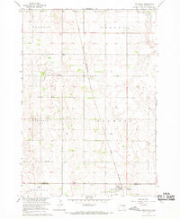
1956 Map of Hitchcock SE
USGS Topo · Published 1958About this map
The James River meanders through the northeastern corner of this Beadle County landscape, where the flat plains are organized into the distinct townships of Altoona, Pleasant View, Broadland, and Fairfield. This mid-century survey illustrates a classic Midwestern agrarian grid, punctuated by vital community anchors such as the Marshall Sch and Mc Daniel Sch.
Find a feature on this map
14 named features on this map. Tap any name to fly to it.
Don’t see what you’re looking for? This feature index may not catch every label — zoom into the map to look around manually.
Map Details
Editions of this 1956 Hitchcock SE Map
This is the sole edition of this map. No revisions or reprints were ever made.
Other maps of this area

1895 · Byron
USGS Topo · 1:125,000

1898 · Huron
USGS Topo · 1:125,000

1953 · Huron
USGS Topo · 1:250,000

1954 · Huron
USGS Topo · 1:250,000

1956 · Lake Byron NW
USGS Topo · 1:24,000

1956 · Lake Byron
USGS Topo · 1:24,000

1956 · Spink Colony
USGS Topo · 1:24,000

1958 · Huron NW
USGS Topo · 1:24,000

1967 · Hitchcock SW
USGS Topo · 1:24,000
1967 · Hitchcock
USGS Topo · 1:24,000