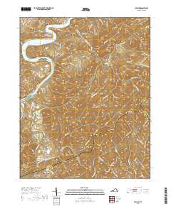
2019 Map of Hiwassee
USGS Topo · Published 2019About this map
Hiwassee and the New River corridor define the landscape of this Pulaski County region, where the river widens into the waters of Claytor Lake. The topography is marked by a complex system of ridges and hollows, including Jersey Ridge and Matheny Hollow, which separate the major river valleys. Along the southern reaches, Big Reed Island Creek winds through the hills near the historic community of Allisonia.
Find a feature on this map
104 named features on this map. Tap any name to fly to it.
Don’t see what you’re looking for? This feature index may not catch every label — zoom into the map to look around manually.
Map Details
Editions of this 2019 Hiwassee Map
This is the sole edition of this map. No revisions or reprints were ever made.
Other maps of this area

1889 · Hillsville
USGS Topo · 1:125,000

1890 · Dublin
USGS Topo · 1:125,000

1891 · Dublin
USGS Topo · 1:125,000

1892 · Hillsville
USGS Topo · 1:125,000

1896 · Hillsville
USGS Topo · 1:125,000

1930 · Max Meadows
USGS Topo · 1:62,500

1934 · Pulaski
USGS Topo · 1:48,000

1940 · Pulaski
USGS Topo · 1:62,500

1950 · Radford
USGS Topo · 1:62,500

1953 · Winston-Salem
USGS Topo · 1:250,000