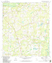
1982 Map of Hobbs Crossroads
USGS Topo · Published 1993About this map
The Alabama-Florida state line bisects this landscape, where the Pea River and Choctawhatchee River define the local drainage patterns. Small rural communities like Sweet Gum Head and Hobbs Crossroads anchor the region, characterized by a network of family-named cemeteries and country churches. The map documents numerous landmarks essential to the local social fabric, including Hurricane Creek Church, Beulah Anna Church, and the McDuffie Cemetery. Near the southern bend of the Choctawhatchee, the Old Warehouse Landing suggests a history of river-based commerce and transit. The terrain is marked by numerous ponds and branches, such as Bakers Pond and Pine Log Creek, illustrating the well-watered character of the Gulf Coastal Plain before modern development altered these traditional drainage systems.
Find a feature on this map
65 named features on this map. Tap any name to fly to it.
Don’t see what you’re looking for? This feature index may not catch every label — zoom into the map to look around manually.
Map Details
Editions of this 1982 Hobbs Crossroads Map
3 editions found
Other maps of this area

1942 · Enterprise
USGS Topo · 1:125,000

1949 · Glendale
USGS Topo · 1:62,500

1949 · Hobbs Crossroads
USGS Topo · 1:24,000

1949 · Caryville
USGS Topo · 1:24,000

1950 · Hobbs Cross Roads
USGS Topo · 1:24,000

1950 · Prosperity
USGS Topo · 1:24,000

1950 · Caryville
USGS Topo · 1:24,000

1950 · Izagora
USGS Topo · 1:24,000

1951 · Glendale
USGS Topo · 1:62,500

1953 · Andalusia
USGS Topo · 1:250,000