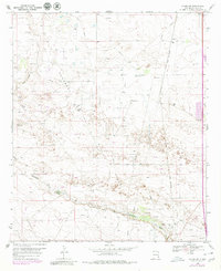
1969 Map of Hobbs SW
USGS Topo · Published 1980About this map
White Breaks defines the northwestern reaches of this West Texas and New Mexico borderlands survey, where the arid Permian Basin landscape is etched with complex industrial infrastructure. The extraction economy is pervasive, documented through a dense network of oil wells, scattered gravel pits, and an extensive aqueduct and pipeline system. Small settlements and industrial sites like Warren and the Carbon Plant are linked by these utilities, showing the region's focus on resource management in the late 1960s. The ephemeral hydrology of the area is visible in the paths of Jal Draw and Monument Draw, which cut across the terrain towards the state line. Near the southern draw, the Monument Cem serves as a localized landmark for genealogists tracing families connected to the early ranching and petroleum developments of Lea County.
Find a feature on this map
16 named features on this map. Tap any name to fly to it.
Don’t see what you’re looking for? This feature index may not catch every label — zoom into the map to look around manually.
Map Details
Editions of this 1969 Hobbs SW Map
2 editions found
Other maps of this area

1954 · Hobbs
USGS Topo · 1:250,000

1958 · Hobbs
USGS Topo · 1:250,000

1963 · Oil Center
USGS Topo · 1:62,500

1963 · Monument
USGS Topo · 1:62,500

1969 · Hobbs SW
USGS Topo · 1:24,000

1969 · Hobbs East
USGS Topo · 1:24,000

1969 · Eunice
USGS Topo · 1:24,000

1969 · Hobbs SE
USGS Topo · 1:24,000

1969 · Eunice NE
USGS Topo · 1:24,000

1969 · Hobbs West
USGS Topo · 1:24,000