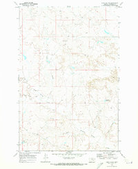
1969 Map of Hobo Coulee
USGS Topo · Published 1973About this map
South Sunday Creek and its tributaries carve a complex drainage system through this portion of Rosebud County, as documented by 1968 aerial photography and 1969 field checks. The landscape is defined by the intermittent flow of Hobo Coulee and Rose Coulee, reflecting the arid nature of the Montana prairie. Human presence is sparse, marked primarily by ranching and resource exploration infrastructure, including a specific Drill Hole and the Donald Reservoir. The terrain around Bannister consists of an intricate network of coulees and ridges typical of the northern Great Plains, where water management is critical for land use. The map reveals the relationship between topography and the seasonal watercourses of Coal Creek, providing a detailed look at the rural character and land division in the late 1960s.
Find a feature on this map
7 named features on this map. Tap any name to fly to it.
Don’t see what you’re looking for? This feature index may not catch every label — zoom into the map to look around manually.
Map Details
Editions of this 1969 Hobo Coulee Map
This is the sole edition of this map. No revisions or reprints were ever made.
Other maps of this area

1954 · Forsyth
USGS Topo · 1:250,000

1957 · Forsyth
USGS Topo · 1:250,000

1958 · Forsyth
USGS Topo · 1:250,000

1968 · Sand Buttes
USGS Topo · 1:24,000

1968 · Butterfly Creek
USGS Topo · 1:24,000

1968 · Hathaway NW
USGS Topo · 1:24,000
1969 · Angela NE
USGS Topo · 1:24,000

1969 · Wild Horse Pass SE
USGS Topo · 1:24,000
1969 · N Bar Coulee
USGS Topo · 1:24,000
1969 · Alkali Creek
USGS Topo · 1:24,000