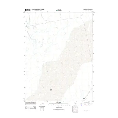
2011 Map of Hog Spring
USGS Topo · Published 2011About this map
The vast, arid expanse of the Smoke Creek Desert dominates this northwestern Nevada landscape, where water sources like Hog Spring and Buffalo Slough dictated the placement of early 20th-century ranching outposts. The presence of the Old Heller Ranch in the northwest corner and the remote station at Reynard in the southeast highlights the thin thread of human activity in this harsh environment. Historically, these locations served as vital stops for those navigating the edge of the alkali flats. Surface transportation is defined by rugged corridors like Buffalo Meadows Rd and Smoke Creek Rd, which trace ancient paths through Washoe County. This survey provides a precise look at the drainage patterns and topography of the high desert basin before modern development could alter these isolated landmarks.
Find a feature on this map
7 named features on this map. Tap any name to fly to it.
Don’t see what you’re looking for? This feature index may not catch every label — zoom into the map to look around manually.
Map Details
Editions of this 2011 Hog Spring Map
This is the sole edition of this map. No revisions or reprints were ever made.
Other maps of this area

1886 · Granite Range
USGS Topo · 1:250,000

1894 · Granite Range
USGS Topo · 1:250,000

1955 · Lovelock
USGS Topo · 1:250,000

1959 · Lovelock
USGS Topo · 1:250,000

1965 · Fox Range
USGS Topo · 1:62,500

1980 · Salt Marsh
USGS Topo · 1:24,000
1980 · Buffalo Creek
USGS Topo · 1:24,000

1980 · Hog Spring
USGS Topo · 1:24,000

1980 · Wall Spring
USGS Topo · 1:24,000

1980 · Smith Canyon
USGS Topo · 1:24,000