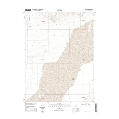
2014 Map of Hog Spring
USGS Topo · Published 2014About this map
The Smoke Creek Desert dominates the southeastern expanse of this Washoe County survey, illustrating the stark, arid character of the Nevada landscape. This region of the Great Basin is defined by low-lying basins and ephemeral water sources like the isolated Hog Spring and the drainage of Buffalo Slough. Access through this remote territory is maintained by sparse infrastructure, primarily Surprise Valley Rd and Buffalo Meadows Rd, which trace the periphery of the playa. In the southern reach, the small siding or geographic point of Reynard provides a specific reference point along the transportation corridor that skirted the desert's edge. The map captures the meticulous township and range grid system, showing the surveyed divisions of T31N R20E through T32N R21E across this uninhabited stretch of the High Desert.
Find a feature on this map
12 named features on this map. Tap any name to fly to it.
Don’t see what you’re looking for? This feature index may not catch every label — zoom into the map to look around manually.
Map Details
Editions of this 2014 Hog Spring Map
This is the sole edition of this map. No revisions or reprints were ever made.
Other maps of this area

1886 · Granite Range
USGS Topo · 1:250,000

1894 · Granite Range
USGS Topo · 1:250,000

1955 · Lovelock
USGS Topo · 1:250,000

1959 · Lovelock
USGS Topo · 1:250,000

1965 · Fox Range
USGS Topo · 1:62,500

1980 · Salt Marsh
USGS Topo · 1:24,000
1980 · Buffalo Creek
USGS Topo · 1:24,000

1980 · Hog Spring
USGS Topo · 1:24,000

1980 · Wall Spring
USGS Topo · 1:24,000

1980 · Smith Canyon
USGS Topo · 1:24,000