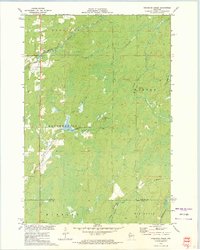
1972 Map of Hogsback Creek
USGS Topo · Published 1975About this map
The Brunet River and its network of tributaries define the wooded landscape across the borders of Sawyer and Rusk counties in the early 1970s. This survey records the industrial and transportation footprints of northern Wisconsin, marked by the presence of numerous Gravel Pits and relic transportation corridors like the Old Railroad Grade and the Bissell Grade. The terrain is characterized by a dense system of creeks including Hogsback Creek, Nail Creek, and Tupper Creek, which drain into the Thornapple River system. Human presence is largely concentrated along transit lines, with the Swayne Lookout Tower providing a high point for forest management. The survey documents the rural township boundaries of Meadowbrook, Radisson, and Big Falls, showing a region shaped by timber history and the transition toward the contemporary recreation and resource management era.
Find a feature on this map
21 named features on this map. Tap any name to fly to it.
Don’t see what you’re looking for? This feature index may not catch every label — zoom into the map to look around manually.
Map Details
Editions of this 1972 Hogsback Creek Map
This is the sole edition of this map. No revisions or reprints were ever made.
Other maps of this area

1944 · Exeland
USGS Topo · 1:48,000

1944 · Draper
USGS Topo · 1:48,000

1944 · Radisson
USGS Topo · 1:48,000

1945 · Ingram
USGS Topo · 1:48,000

1947 · Exeland
USGS Topo · 1:48,000

1947 · Ingram
USGS Topo · 1:48,000

1947 · Draper
USGS Topo · 1:48,000

1949 · Radisson
USGS Topo · 1:48,000

1953 · Rice Lake
USGS Topo · 1:250,000

1959 · Rice Lake
USGS Topo · 1:250,000