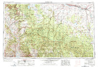
1954 Map of Holbrook
USGS Topo · Published 1973About this map
The Mogollon Rim dominates the central landscape of this 1954 survey, marking the dramatic transition between the high plateau and the southern river valleys. This topographic study captures a region of vast national forests and tribal lands, including the Fort Apache Indian Reservation and the Coconino National Forest. Along the northern corridor, the Atchison Topeka & Santa Fe RR parallels U.S. 66 through Holbrook and Joseph City, serving as a vital transportation artery for the cattle and timber industries of the era.
Find a feature on this map
130 named features on this map. Tap any name to fly to it.
Don’t see what you’re looking for? This feature index may not catch every label — zoom into the map to look around manually.
Map Details
Editions of this 1954 Holbrook Map
3 editions found

Other maps of this area

1883 · Tusayan
USGS Topo · 1:250,000

1886 · St Johns
USGS Topo · 1:250,000

1886 · Tusayan
USGS Topo · 1:250,000

1886 · Fort Defiance
USGS Topo · 1:250,000

1886 · San Francisco Mtns
USGS Topo · 1:250,000

1886 · Chino
USGS Topo · 1:250,000

1886 · Holbrook
USGS Topo · 1:250,000

1887 · Verde
USGS Topo · 1:250,000

1887 · Prescott
USGS Topo · 1:250,000

1891 · San Francisco Mtns
USGS Topo · 1:250,000