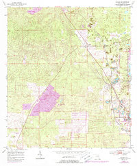
1954 Map of Holder
USGS Topo · Published 1988About this map
Beverly Hills and Citrus Springs anchor the northwestern reaches of this Florida survey, reflecting the expansion of mid-century residential footprints. The landscape is heavily marked by the region's extractive history, with numerous unnamed Mine sites concentrated along the eastern edge near Seaboll and Calphos. These industrial features are set against the complex shoreline of Tsala Apopka Lake and the nearby Prairie Lake.
Find a feature on this map
21 named features on this map. Tap any name to fly to it.
Don’t see what you’re looking for? This feature index may not catch every label — zoom into the map to look around manually.
Map Details
Editions of this 1954 Holder Map
3 editions found
Other maps of this area

1892 · Dunnellon
USGS Topo · 1:62,500

1894 · Dunnellon
USGS Topo · 1:62,500

1895 · Tsala Apopka
USGS Topo · 1:62,500

1954 · Lecanto
USGS Topo · 1:24,000

1954 · Homosassa
USGS Topo · 1:24,000

1954 · Holder
USGS Topo · 1:24,000

1954 · Crystal River
USGS Topo · 1:24,000

1954 · Tsala Apopka NE
USGS Topo · 1:24,000

1954 · Dunnellon
USGS Topo · 1:24,000

1954 · Inverness
USGS Topo · 1:24,000