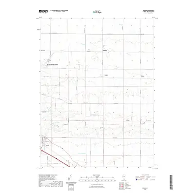
2021 Map of Holder
USGS Topo · Published 2021About this map
Kickapoo Cr and Money Cr wind through the agricultural landscape of McLean County, defining the drainage patterns that shaped the early layout of this central Illinois region. The eastern outskirts of Bloomington transition into a structured grid of rural roads, including Bentown Rd and N 2100 East Rd, which connect several small, historic settlements. Locations such as Bentown, Holder, and Padua serve as local landmarks along the transit corridors, while Downs occupies the southern reaches near the fork of Little Kickapoo Cr. For genealogists, the map is particularly valuable for its placement of several rural burial grounds, including Benjaminville Cem near Bentown, Pleasant Grove Cem, and Lebo Cem. This 2021 study illustrates how modern infrastructure and legacy farmsteads coexist in a prairie landscape that has remained remarkably consistent in its settlement distribution over the decades.
Find a feature on this map
54 named features on this map. Tap any name to fly to it.
Don’t see what you’re looking for? This feature index may not catch every label — zoom into the map to look around manually.
Map Details
Editions of this 2021 Holder Map
This is the sole edition of this map. No revisions or reprints were ever made.
Other maps of this area

1926 · Normal
USGS Topo · 1:62,500

1930 · Normal
USGS Topo · 1:62,500

1951 · Le Roy
USGS Topo · 1:62,500

1952 · Arrowsmith
USGS Topo · 1:62,500

1957 · Colfax
USGS Topo · 1:62,500

1958 · Peoria
USGS Topo · 1:250,000

1961 · Peoria
USGS Topo · 1:250,000

1963 · Peoria
USGS Topo · 1:250,000
1981 · Heyworth
USGS Topo · 1:24,000
1981 · Holder
USGS Topo · 1:24,000