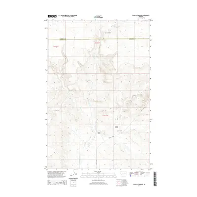
2014 Map of Hole-in-the-Rock
USGS Topo · Published 2014About this map
Hole-in-the-Rock serves as the namesake and central point for this high-plains landscape where the Garfield Co and Rosebud Co line crosses open ranchland. The geography is defined by a complex network of drainages, including Big Porcupine Creek and its tributary Indian Cr, which have carved deep into the terrain to form landmarks like Devils Canyon. The map reveals the intricate natural erosion of the Missouri Plateau, with names like Germo Coulee and Hanson Coulee signifying the importance of these seasonal watercourses to local orientation. Rural infrastructure is minimal, consisting primarily of gravel arteries such as Shoup Rd and Acorn Flats Rd, providing essential access to this sparsely populated stretch of Big Sky Country.
Find a feature on this map
14 named features on this map. Tap any name to fly to it.
Don’t see what you’re looking for? This feature index may not catch every label — zoom into the map to look around manually.
Map Details
Editions of this 2014 Hole-in-the-Rock Map
This is the sole edition of this map. No revisions or reprints were ever made.
Other maps of this area

1954 · Forsyth
USGS Topo · 1:250,000

1957 · Forsyth
USGS Topo · 1:250,000

1958 · Forsyth
USGS Topo · 1:250,000

1960 · Hagen Ranch
USGS Topo · 1:24,000

1960 · Brown Coulee
USGS Topo · 1:24,000

1960 · Black Sea Reservoir
USGS Topo · 1:24,000

1965 · Acorn Flats
USGS Topo · 1:24,000

1965 · Kramer Ranch
USGS Topo · 1:24,000

1965 · Hole-In-The-Rock
USGS Topo · 1:24,000
1965 · Emma Butte
USGS Topo · 1:24,000