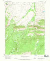
1967 Map of Hole In The Rock
USGS Topo · Published 1970About this map
The Wasatch National Forest dominates this high-altitude landscape along the border of Uinta and Summit Counties. The area is defined by the complex drainage network of Beaver Creek, where the West Fork, Middle Fork, and East Fork converge near the geological formation and landmark known as Hole in the Rock. This 1967 field-checked survey reveals a backcountry transition from the low-lying Gregory Basin up toward the prominent Bald Range and Burnt Ridge.
Find a feature on this map
30 named features on this map. Tap any name to fly to it.
Don’t see what you’re looking for? This feature index may not catch every label — zoom into the map to look around manually.
Map Details
Editions of this 1967 Hole In The Rock Map
2 editions found
Other maps of this area

1885 · Uinta
USGS Topo · 1:250,000

1905 · Gilbert Peak
USGS Topo · 1:125,000

1906 · Gilbert Peak
USGS Topo · 1:125,000

1954 · Salt Lake City
USGS Topo · 1:250,000

1954 · Ogden
USGS Topo · 1:250,000

1958 · Ogden
USGS Topo · 1:250,000

1958 · Salt Lake City
USGS Topo · 1:250,000

1960 · Ogden
USGS Topo · 1:250,000

1960 · Salt Lake City
USGS Topo · 1:250,000
1964 · Lonetree
USGS Topo · 1:24,000