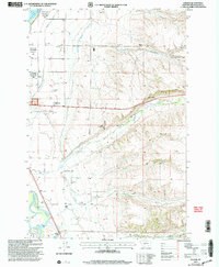
2001 Map of Holker
USGS Topo · Published 2004About this map
Canyon Ferry Lake and the Missouri River define the western corridor of this Broadwater County landscape as it appeared at the turn of the 21st century. The map illustrates a complex water management and agricultural network, featuring the Missouri Broadwater Canal, Fairchild Ditch, and Montana Ditch which feed the local valley. Notable family holdings like Daniels Ranch and Welch Ranch sit alongside community hubs including the Rodeo Ground and Townsend Airport. For genealogists, the map identifies specific burial sites such as Holy Cross Cem and Deep Creek Cem. The transition from the river valley into the foothills is marked by the Helena National Forest boundary and several seasonal drainages like Cottonwood Creek and Boone Run, highlighting the intersection of public land and private ranching.
Find a feature on this map
29 named features on this map. Tap any name to fly to it.
Don’t see what you’re looking for? This feature index may not catch every label — zoom into the map to look around manually.
Map Details
Editions of this 2001 Holker Map
This is the sole edition of this map. No revisions or reprints were ever made.
Other maps of this area

1886 · Fort Logan
USGS Topo · 1:250,000

1948 · White Sulphur Springs
USGS Topo · 1:250,000

1949 · Radersburg
USGS Topo · 1:62,500

1949 · Toston
USGS Topo · 1:62,500

1950 · Townsend
USGS Topo · 1:62,500

1950 · Duck Creek Pass
USGS Topo · 1:62,500

1958 · White Sulphur Springs
USGS Topo · 1:250,000

1961 · White Sulphur Springs
USGS Topo · 1:250,000

1965 · White Sulphur Springs
USGS Topo · 1:250,000

1976 · Townsend
USGS Topo · 1:100,000