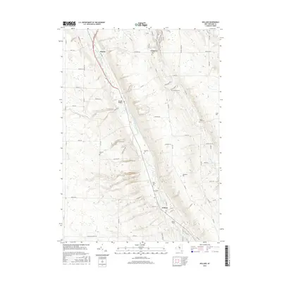
2016 Map of Holland
USGS Topo · Published 2016About this map
East Branch Cazenovia Creek carves a significant valley through this portion of Erie County, dictating the placement of settlements and transport corridors like the Aurora Expy. The village of Holland serves as a southern anchor, while the hamlet of South Wales occupies a central position where the creek valley narrows. The surrounding uplands are defined by high-elevation features such as Cherrywood Ridge and Crow Hill, which provide a contrast to the deep incision of Gears Gulf near the southern boundary.
Find a feature on this map
64 named features on this map. Tap any name to fly to it.
Don’t see what you’re looking for? This feature index may not catch every label — zoom into the map to look around manually.
Map Details
Editions of this 2016 Holland Map
This is the sole edition of this map. No revisions or reprints were ever made.
Other maps of this area

1905 · Attica
USGS Topo · 1:62,500

1905 · Depew
USGS Topo · 1:62,500

1923 · Arcade
USGS Topo · 1:62,500

1925 · Springville
USGS Topo · 1:62,500

1925 · Arcade
USGS Topo · 1:62,500

1948 · Depew
USGS Topo · 1:62,500

1949 · Attica
USGS Topo · 1:62,500

1949 · Cowlesville
USGS Topo · 1:24,000
1950 · Orchard Park
USGS Topo · 1:24,000
1950 · East Aurora
USGS Topo · 1:24,000