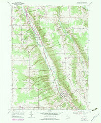
1979 Map of Holland
USGS Topo · Published 1979About this map
East Branch Cazenovia Creek carves a central corridor through this section of Erie County, dictating the settlement patterns of South Wales and the township of Holland. The landscape is defined by its dramatic relief, rising from the creek valley to the high points of Vermont Hill and Crow Hill. Cultural and family history is deeply rooted here, evidenced by numerous small burial grounds such as Holmes Cem, Neischel Cem, and Goodleberg Cem scattered across the uplands.
Find a feature on this map
43 named features on this map. Tap any name to fly to it.
Don’t see what you’re looking for? This feature index may not catch every label — zoom into the map to look around manually.
Map Details
Editions of this 1979 Holland Map
This is the sole edition of this map. No revisions or reprints were ever made.
Other maps of this area

1905 · Attica
USGS Topo · 1:62,500

1905 · Depew
USGS Topo · 1:62,500

1923 · Arcade
USGS Topo · 1:62,500

1925 · Springville
USGS Topo · 1:62,500

1925 · Arcade
USGS Topo · 1:62,500

1948 · Depew
USGS Topo · 1:62,500

1949 · Attica
USGS Topo · 1:62,500

1949 · Cowlesville
USGS Topo · 1:24,000
1950 · Orchard Park
USGS Topo · 1:24,000
1950 · East Aurora
USGS Topo · 1:24,000