
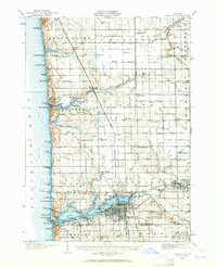
1929 Map of Holland
USGS Topo · Published 1959About this map
The Lake Michigan shoreline dominates this 1920s survey, defined by a string of beaches and summer developments such as Zwemmer Beach, Rosabelle Beach, and Tennessee Beach. Inland, the landscape transition is marked by the expansive Lake Macatawa and its connection to Macatawa Bay, where the city of Holland is established with a dense street grid and significant waterfront infrastructure. The era's transportation relies heavily on the Pere Marquette railroad, which links the outlying farming communities and specialized sites like Getz Lakewood Farm.
Find a feature on this map
94 named features on this map. Tap any name to fly to it.
Don’t see what you’re looking for? This feature index may not catch every label — zoom into the map to look around manually.
Map Details
Editions of this 1929 Holland Map
2 editions found
Other maps of this area

1928 · Fennville
USGS Topo · 1:62,500

1930 · Lake Harbor
USGS Topo · 1:48,000

1930 · Muskegon
USGS Topo · 1:62,500

1931 · Fennville
USGS Topo · 1:62,500

1932 · Holland
USGS Topo · 1:62,500

1936 · Muskegon
USGS Topo · 1:62,500

1936 · Lake Harbor
USGS Topo · 1:62,500

1945 · Ravenna
USGS Topo · 1:62,500

1954 · Milwaukee
USGS Topo · 1:250,000

1954 · Midland
USGS Topo · 1:250,000