
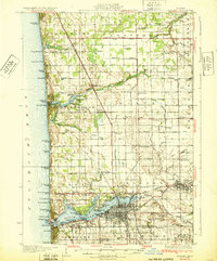
1932 Map of Holland
USGS Topo · Published 1932About this map
Lake Michigan dominates the western edge of this coastal survey, where massive dunes and sand formations separate the lake from a network of inland bayous and rivers. The city of Holland is the primary hub, situated at the eastern end of Black Lake and Macatawa Bay. The landscape is a patchwork of small agricultural settlements and rural schoolhouses, such as Noordeloos, New Holland, and Harlem. The shoreline is heavily developed with seasonal destinations and camps, including Macatawa, Camp Blodgett, and Wakantanka Lodge. Transport is defined by the Pere Marquette RR cutting north-south through the center of the sheet, connecting towns like West Olive and Agnew. The mapping of drainage systems like the Worley Drain and Sawyer Drain reveals the intensive land management required to support the region's farms and orchards during the early twentieth century.
Find a feature on this map
108 named features on this map. Tap any name to fly to it.
Don’t see what you’re looking for? This feature index may not catch every label — zoom into the map to look around manually.
Map Details
Editions of this 1932 Holland Map
2 editions found
Other maps of this area

1928 · Fennville
USGS Topo · 1:62,500

1929 · Holland
USGS Topo · 1:62,500

1930 · Lake Harbor
USGS Topo · 1:48,000

1930 · Muskegon
USGS Topo · 1:62,500

1931 · Fennville
USGS Topo · 1:62,500

1936 · Muskegon
USGS Topo · 1:62,500

1936 · Lake Harbor
USGS Topo · 1:62,500

1945 · Ravenna
USGS Topo · 1:62,500

1954 · Milwaukee
USGS Topo · 1:250,000

1954 · Midland
USGS Topo · 1:250,000