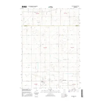
2016 Map of Hollandale
USGS Topo · Published 2016About this map
Hollandale serves as the central hub for this agricultural landscape along the border of Steele and Freeborn counties. The terrain is defined by an extensive network of water management, where natural flows like Mud Cr and Turtle Cr are integrated with an engineered system of drainage, including Judicial Ditch Number Twentyseven and Judicial Ditch Number Thirty. This pattern of ditches and branches, such as Knotvold Br and Peterson Br, illustrates the intensive modification of the local hydrology to support the region's fertile farmland.
Find a feature on this map
58 named features on this map. Tap any name to fly to it.
Don’t see what you’re looking for? This feature index may not catch every label — zoom into the map to look around manually.
Map Details
Editions of this 2016 Hollandale Map
This is the sole edition of this map. No revisions or reprints were ever made.
Other maps of this area

1954 · Albert Lea
USGS Topo · 1:62,500

1954 · Hayward
USGS Topo · 1:62,500

1954 · Mason City
USGS Topo · 1:250,000

1957 · Mason City
USGS Topo · 1:250,000

1958 · Mason City
USGS Topo · 1:250,000

1967 · Steele Center
USGS Topo · 1:24,000

1967 · Bixby
USGS Topo · 1:24,000

1967 · Blooming Prairie
USGS Topo · 1:24,000

1967 · Hollandale
USGS Topo · 1:24,000
1967 · Hope
USGS Topo · 1:24,000