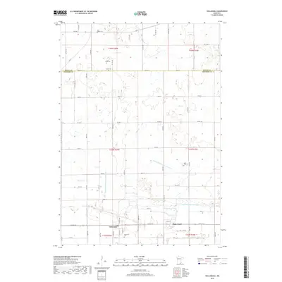
2019 Map of Hollandale
USGS Topo · Published 2019About this map
Hollandale sits at the junction of State Hwy 251 and Center Ave, surrounded by the highly engineered drainage landscape of southern Minnesota. The terrain is defined by a dense network of artificial waterways, including the Judicial Ditch Number Twentyeight, Judicial Ditch Number Twentyseven, and Judicial Ditch Number Thirty, which channel water from Mud Cr and Turtle Cr across the flat agricultural expanse. To the east, the small settlement of Maple Island remains a notable landmark on the road to Deer Cr. For genealogists, the map is particularly rich in family history details, noting several small burial grounds such as the Clark Family Cem, Summit Cem, and the church-affiliated Saint Marys Cem. The boundary between Steele and Freeborn counties cuts across the northern section, dividing the townships of t105n r20w and t104n r20w.
Find a feature on this map
62 named features on this map. Tap any name to fly to it.
Don’t see what you’re looking for? This feature index may not catch every label — zoom into the map to look around manually.
Map Details
Editions of this 2019 Hollandale Map
This is the sole edition of this map. No revisions or reprints were ever made.
Other maps of this area

1954 · Albert Lea
USGS Topo · 1:62,500

1954 · Hayward
USGS Topo · 1:62,500

1954 · Mason City
USGS Topo · 1:250,000

1957 · Mason City
USGS Topo · 1:250,000

1958 · Mason City
USGS Topo · 1:250,000

1967 · Steele Center
USGS Topo · 1:24,000

1967 · Bixby
USGS Topo · 1:24,000

1967 · Blooming Prairie
USGS Topo · 1:24,000

1967 · Hollandale
USGS Topo · 1:24,000
1967 · Hope
USGS Topo · 1:24,000