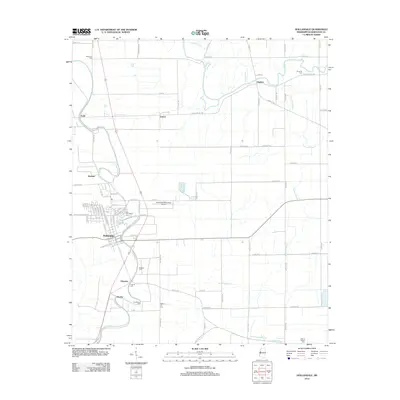
2012 Map of Hollandale
USGS Topo · Published 2012About this map
Hollandale serves as the central hub of this Mississippi Delta landscape, where a dense network of local roads such as Delta City Rd and Watson Rd connect the town to outlying agricultural settlements. The terrain is defined by the winding paths of Bogue Phalia, Deer Cr, and Fourmile Bayou, which weave through the flat alluvial plain. Smaller communities like Darlove, Estill, and Empire are scattered throughout, often associated with family-named burial grounds that provide significant genealogical value. These include Magruder Cem and Huddleston Cem, alongside the New Foundation Cem in the heart of Hollandale. The presence of the Hollandale Municipal Airport near the town center and the systematic grid of section roads reflect the enduring intersection of rural aviation and Delta farming traditions.
Find a feature on this map
86 named features on this map. Tap any name to fly to it.
Don’t see what you’re looking for? This feature index may not catch every label — zoom into the map to look around manually.
Map Details
Editions of this 2012 Hollandale Map
This is the sole edition of this map. No revisions or reprints were ever made.
Other maps of this area

1939 · Tralake
USGS Topo · 1:62,500

1939 · Swan Lake
USGS Topo · 1:62,500

1940 · Auter
USGS Topo · 1:62,500

1940 · Baird
USGS Topo · 1:62,500

1953 · Greenwood
USGS Topo · 1:250,000

1956 · Greenwood
USGS Topo · 1:250,000
1965 · Richey
USGS Topo · 1:24,000

1965 · Kinlock
USGS Topo · 1:24,000
1965 · Midnight NW
USGS Topo · 1:24,000

1967 · Baird
USGS Topo · 1:62,500