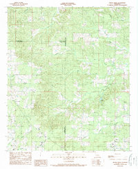
1989 Map of Hollis Creek
USGS Topo · Published 1989About this map
The Parish borders of De Soto, Sabine, and Natchitoches intersect in this 1980s landscape, where a network of bayous and creeks defines the drainage of north-central Louisiana. The map reveals a working landscape characterized by an active Oil Field and communication infrastructure, including a Lookout Tower and Radio Tower. Residential development is sparse, primarily concentrated near small crossings like Stacy and Dobs Crossing.
Find a feature on this map
19 named features on this map. Tap any name to fly to it.
Don’t see what you’re looking for? This feature index may not catch every label — zoom into the map to look around manually.
Map Details
Editions of this 1989 Hollis Creek Map
This is the sole edition of this map. No revisions or reprints were ever made.
Other maps of this area

1938 · Chemard Lake
USGS Topo · 1:31,680

1938 · Hollis Creek
USGS Topo · 1:31,680

1938 · Allen
USGS Topo · 1:31,680

1938 · Lake End
USGS Topo · 1:31,680

1941 · Zwolle
USGS Topo · 1:62,500

1941 · Pelican
USGS Topo · 1:62,500

1942 · Many
USGS Topo · 1:62,500

1943 · Many
USGS Topo · 1:62,500

1943 · Pleasant Hill
USGS Topo · 1:62,500

1944 · Zwolle
USGS Topo · 1:62,500